Field Work Trash or Treasure? As humans have explored the Antarctic wilderness further, their impact on it has become more…Edmund StumpNovember 1, 2012
News Fall Break For the first time this semester Arizona State has had a Fall Break. Regina came…Edmund StumpOctober 1, 2012
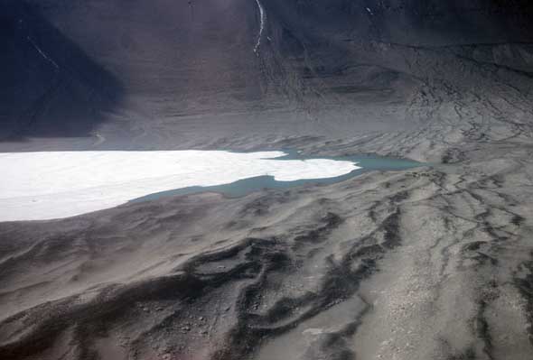
Field WorkNews The Remote Heart of the Transantarctic Mountains A glacier flows through the remote heart of the Transantarctic Mountains, a land so alien…Edmund StumpSeptember 1, 2012
ClimbingField Work The Aesthetics of Field Science This month marks the first anniversary of my blog. The following is an abridgement of…Edmund StumpAugust 1, 2012
News Gone Fishin’ Vacationing this month. I’ll be back to business in August.Edmund StumpJuly 1, 2012
Antarctic ExplorersClimbingField WorkNews The Unknown What is it about the unknown? Why are we drawn to it? Why the fascination?…Edmund StumpJune 1, 2012
News Cadillac Jack and the Whiteout Thanks to its extremely low humidity, the Antarctic atmosphere allows the sun to shine with…Edmund StumpMay 1, 2012
ClimbingField Work Antarctica in the Summer: Sunshine 24/7 A peculiarity of the polar regions is the cycle of seasons with total darkness and…Edmund StumpApril 1, 2012
News The Greening of McMurdo Station, Antarctica During the 1955-56 Antarctic summer season in preparation for the International Geophysical Year (1957-58), the…Edmund StumpMarch 1, 2012
News Going Swimming in Antarctica on the Huffington Post My new piece for the Huffington Post titled "Going Swimming In Antarctica By Accident and…Edmund StumpFebruary 5, 2012
ClimbingField Work Climbing for Science in Antarctica Over the past several months I’ve talked a lot about Antarctica and what it’s like…Edmund StumpFebruary 1, 2012
Field WorkNews Geology of the Transantarctic Mountains Last week the holidays broke my routine. As I head into the New Year, The…Edmund StumpJanuary 1, 2012
News Ascent of The Tusk, Liv Glacier, Antarctica People always ask when they see this picture, “Is that you out there?” To which…Edmund StumpDecember 18, 2011
Antarctic Explorers Amundsen Reaches South Pole; Scott Starts up Beardmore Glacier December 14, 1911, 100 years ago this week, the Norwegian party led by Roald Amundsen…Edmund StumpDecember 11, 2011
News Wildlife around McMurdo Station, Antarctica Although McMurdo nightlife can be pretty wild on a Saturday night, wildlife in the general…Edmund StumpDecember 4, 2011
News The Roof at the Bottom of the World Reviewed by The New York Times The Roof at the Bottom of the World has been reviewed by The New York…Edmund StumpDecember 2, 2011
News Field Cuisine in Antarctica You’ve had a hard day in the field climbing mountains, collecting rocks. You're chilled to…Edmund StumpNovember 27, 2011
News Amundsen Takes the Transantarctic Mountains 100 years ago this week Roald Amundsen and his boys hit the Transantarctic Mountains. They…Edmund StumpNovember 20, 2011
News Conquering The Spectre In The Gothic Mountains on The Huffington Post A post I wrote for The Huffington Post titled "Conquering The Spectre In The Gothic…Edmund StumpNovember 19, 2011
News The Ascent of Mount Markham in The Atlantic Despite the lead in to my recent article in The Atlantic, you cannot reach the…Edmund StumpNovember 17, 2011
News The Roof at the Bottom of the World Reviewed by SESE SOURCE My new book, The Roof at the Bottom of the World was recently reviewed by…Edmund StumpNovember 15, 2011
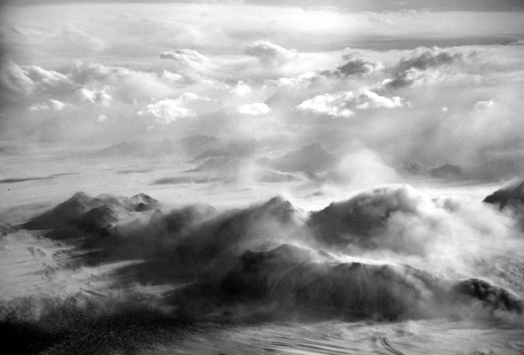
News The Wind In the static, lifeless landscape of the deep field, the wind is the only animate…Edmund StumpNovember 13, 2011
News Remote Helicopter Camps Remote helicopter camps have been a recurring logistic feature of the U. S. Antarctic Program…Edmund StumpNovember 7, 2011
News Crevassing Crevasses are like rattlesnakes--not a problem if you know where they are, but if you…Edmund StumpOctober 30, 2011
News Photography in the Field Last year I bought my first digital camera. Two of the photos in The Roof…Edmund StumpOctober 25, 2011
News The Race Begins October 19, 1911. Late news breaking. This just in. Norwegian Roald Amundsen and his party…Edmund StumpOctober 16, 2011
News Ascent of the Spectre I remember the first time I saw a photos of the Organ Pipe Peaks. It…Edmund StumpOctober 9, 2011
News Adélie Penguins 20 miles north of McMurdo station, at Cape Royds, is the southernmost adélie penguin rookery…Edmund StumpOctober 2, 2011
News Hang Time For decades USAP personnel have not worked Sundays in McMurdo. It gives a chance for…Edmund StumpSeptember 25, 2011
News Topo Base Maps This week I want to talk about what has gone into the creation of the…Edmund StumpSeptember 17, 2011
News Stump’s Tent Camp For field work in the Transantarctic Mountains, whether you are placed there by helicopter from…Edmund StumpSeptember 11, 2011
News The Silence The Antarctic silence is mentioned by many of those who have travelled to the deep…Edmund StumpSeptember 5, 2011
Field Work McMurdo Station As the ship Discovery sailed back from a voyage along the Great Barrier (Ross Ice…Edmund StumpAugust 28, 2011
Field Work Finding Cairns Anyone who travels to the deep field in Antarctica experiences setting foot in places where…Edmund StumpAugust 21, 2011
Field Work Hygene in the Field In the field when it comes to the kitchen, Stump’s first rule is, “No Soap!”…Edmund StumpAugust 14, 2011
Field Work And So It Begins… Perhaps the best way to begin this blog is to tell how I came to…Edmund StumpAugust 7, 2011